Amsterdam – a short history
The growth of a city
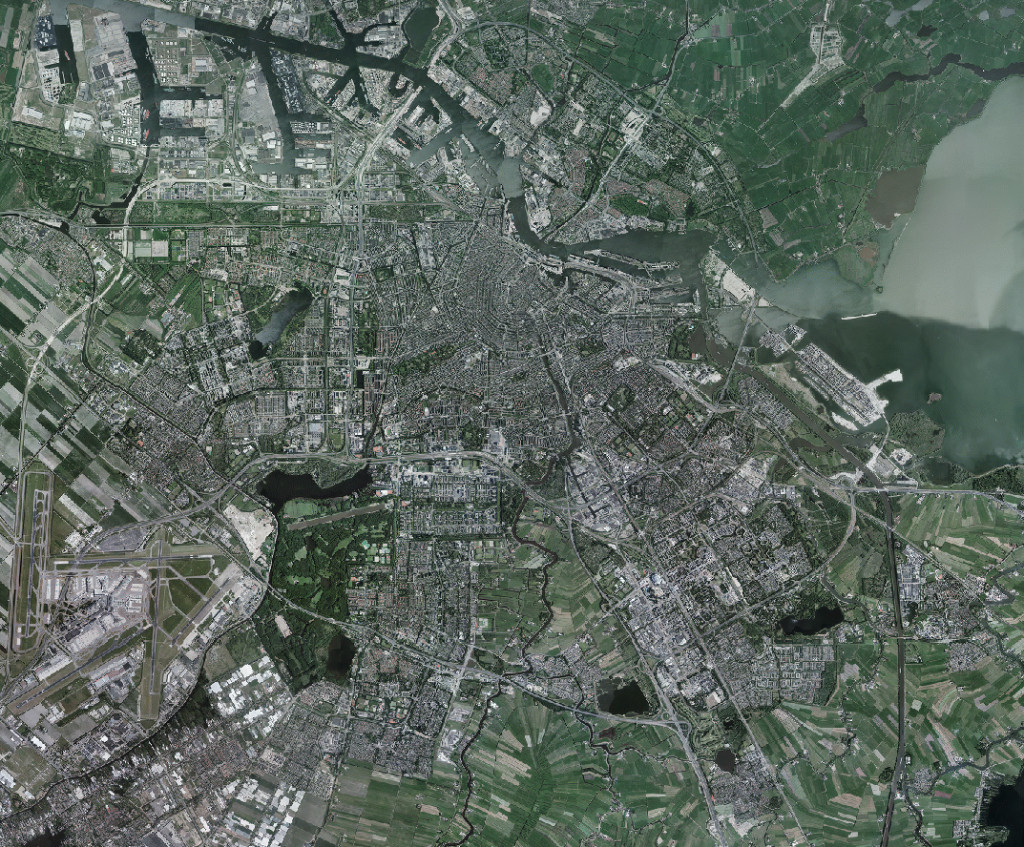
Some seven hundred years ago, at the end of the thirteenth century, a dam was constructed there where the River Amstel flowed into the Zuider Zee. The port of Amsterdam grew up around this dam.
Thanks to trade and fishing, Amsterdam developed and expanded. At the end of the fifteenth century, a wall was built around the city. In the seventeenth century, Amsterdam flourished economically and culturally. The city was enriched by the majestic and characteristic ring of canals, where wealthy merchants settled. The city’s less prosperous inhabitants and small businesses, which were unable to find accommodation along the canals, located in a new district in the west of the city (the Jordaan).
It was some two centuries before any new residential districts were built. In the course of the nineteenth century, the number of inhabitants increased and the resultant housing shortage necessitated further expansion beyond the ring of canals. The ‘Plan Kalff’ (1877) eased the housing shortage, but did not solve all of the city’s problems. In 1917, H.P. Berlage’s ‘Plan Zuid’ was realized – a plan in which the buildings and the design of public space received equal attention. When shortly after its completion it became clear that the city still had a housing shortage, in 1928 the Department of Urban Development was set up. This department was charged with carrying out research into the city’s expected growth up until the year 2000, and this resulted in the Algemeen Uitbreidingsplan (General Extension Plan, AUP) of 1935. On the basis of this plan, the western suburbs and Buitenveldert, as well as recreational areas such as Amsterdamse Bos and Sloterplas, were constructed. The structure plans for Amsterdam-Noord and Zuidoost of 1958 and 1959 can be seen as additions to the AUP.
The last decade of the twentieth century saw the completion of the new residential districts Nieuw Sloten and De Aker. Shortly afterwards, the transformation of the former dock area Oostelijk Havengebied into a residential area was also completed. Today, in 2005, the city is expanding eastwards on new residential islands in the IJmeer, while elsewhere, along the Zuidas (South Axis), the construction of a business city is well underway. The western suburbs Westelijke Tuinsteden are being adapted to meet today’s requirements, a task which is nearing completion in the Bijlmermeer. Close to the city centre, the Southern IJ Waterfront is being redeveloped or refurbished. The expansion of the metro network with the construction of the North/South Line, work on which continues round the clock, will, among other things, give an impetus to the development of Amsterdam Noord and the Northern IJ Waterfront, the plans for which have been drawn up.
A characteristic of Amsterdam is that the many stages in its growth are clearly visible in the cityscape – both in the contrasts between the various districts and in the many individual buildings which are a bridge to the past or even to Amsterdam’s origins. For example, in the middle of this vibrant city, Schreierstoren, St Antoniespoort (de Waag) and Munttoren are reminders of Amsterdam’s very first fortifications.
Glory, decline and new expansion
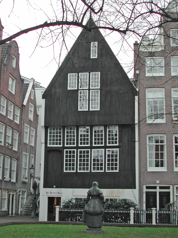
Up until the late Middle Ages, houses in Amsterdam were built of wood and only churches, monasteries and convents were of stone. The wooden house on Begijnhof and the Nieuwe Kerk are silent witnesses. Following a number of major fires in the city, in 1669 the use of wood as a building material was forbidden and brick was introduced. The houses built from this time onwards usually had a basement, a raised ground floor, which was accessed via a separate staircase, and two or more storeys.
The economic disparities and the rich cultural climate in the seventeenth century left their mark on the city’s architecture. It was in this period that the Jordaan – a district whose structure still reflects the original layout of the drainage ditches in the agricultural area around Amsterdam – was built. The narrow streets of the Jordaan accommodated small businesses and houses, which were usually occupied by more than one family, while at the same time, monumental houses and warehouses were being constructed along the city’s canals.
The patrons who commissioned these canal houses, usually wealthy merchants, became interested in Italian Renaissance architecture, and this gave rise in the early seventeenth century to the ‘Dutch Renaissance’ with its rich ornamentation composed of classical and traditional elements.
The lavish decoration soon made way for a strict use of classical elements in ‘Dutch Classicism’. It can be recognized by pilaster orders terminated by a cornice and sometimes a fronton. In the eighteenth century, many seventeenth-century facades were replaced or altered and decorations in Louis styles (imported from France) were often added. The close of the century saw economic decline and a more sober classicism.
During French rule, King Louis Napoleon founded the Prix de Rome, after the French example, in order to promote culture, which had suffered due to the economic decline. This gave architects such as J.D. Zocher jr., J. de Greef and T.F. Suys the opportunity to receive training in Rome and Paris, where the emphasis was on neo-classical architecture. As a result, neo-classicism was introduced into Amsterdam.
In the course of the nineteenth century, the economy improved due to the emergent industries. This was accompanied by a rapid increase in the population of Amsterdam and the city became overcrowded. Because of the insanitary living conditions, a decision was taken in 1850 to start demolishing the city walls and to construct new residential areas beyond Singelgracht. However, ‘Plan Kalff’, which was drawn up to this end, entrusted the new development to private individuals, thereby giving speculators the opportunity to enrich themselves. Consequently, the Pijp, which with its long street frontages and short plots is characteristic of the expansion plan, did little to improve living conditions.
In addition to attention to public housing, in this period deliberate efforts were made to enhance the appearance of the city. For example, an elegant residential area was constructed around Vondelpark. The architect and entrepreneur P.J.H. Cuypers was responsible for designing part of this area. In addition, Cuypers designed the Rijksmuseum, in which he combined neo-Gothic and neo-Renaissance stylistic elements. At the close of the nineteenth century, criticism of the neo-styles increased, led by H.P Berlage. The latter’s Exchange on the Damrak was completed in 1903 and it was to be a turning point in Dutch architecture.
From Housing Act to General Extension Plan
At the close of the nineteenth century, many city dwellers in the Netherlands were still living in deplorable conditions and there were calls for the creation of a statutory framework for public housing. This resulted in the Housing Act, which was important for all further developments. The Act obliged councils to draw up expansion plans and building regulations in which the requirements public housing had to meet were laid down. The first of these expansion plans to be realized in Amsterdam was ‘Plan Zuid’ (1915-1917) by H.P. Berlage.
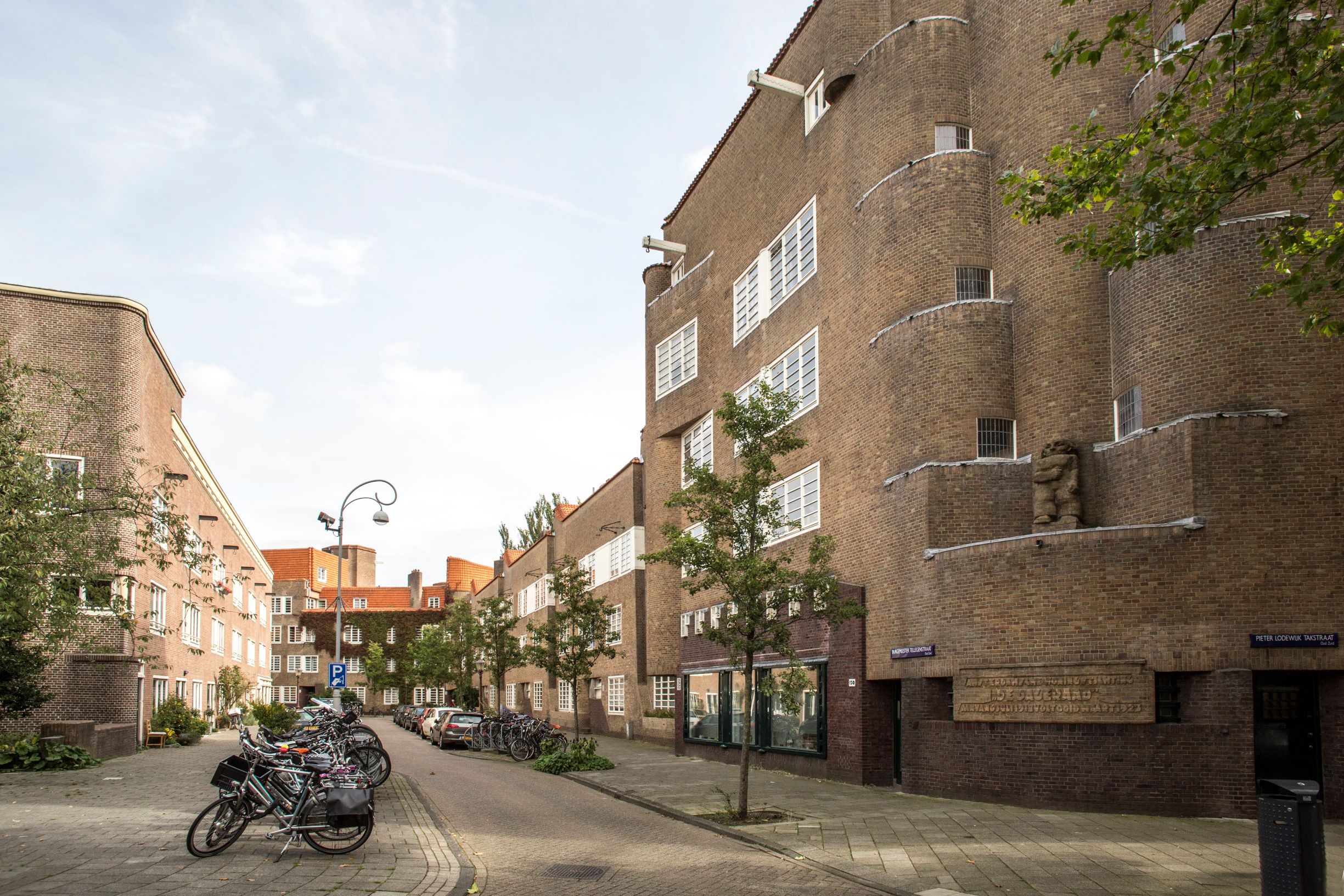
The period in which this plan was realized was also the period of the Amsterdam School and the architects of this school in particular were commissioned by housing corporations to design housing blocks in Amsterdam-Zuid. These architects conceived the block as a large sculpture, the components of which were given a characteristic treatment, without destroying the unity of the whole. Examples of this architecture are the housing complex ‘De Dageraad’ by P.L. Kramer in Amsterdam-Zuid and the housing complex ‘Eigen Haard’ by M. de Klerk in Spaarndammerbuurt.
However, it soon became clear that the Amsterdam School’s building method was too expensive to be deployed on a large scale, and the modern architects of the ‘Nieuwe Bouwen’ movement produced an alternative. They aimed at a sober functionalism, promoted the use of new materials such as concrete, steel and glass, and emphasized the importance of air, light and space in buildings and in the city. Not long after the first signs of a new architecture had become visible in Betondorp (1925-28), Amsterdam witnessed the construction of monuments such as the Cineac and the Open Air School by J. Duiker.
Architects of the Nieuwe Bouwen were also involved in the General Extension Plan which outlined the foundations of the city’s development until the end of the twentieth century and to which the names C. van Eesteren and J. H. Mulder are indissolubly connected. This plan, in which living, working, recreation and traffic are separate, and which is characterized by row housing, was approved by the city council in 1935 but its execution was put on hold due to the outbreak of the Second World War.
New attention to the city centre
After the Second World War, a major house-building programme, based on the General Extension Plan (AUP), was launched in order to ease the housing shortage. In 1951, work started on the realization of the western city expansion and four suburbs (Slotermeer, Geuzenveld, Slotervaart and Osdorp) were built around Sloterplas, constructed in the same period. A characteristic feature of these spacious residential districts is the mix of high-, medium- and low-rise and the presence of open green space.
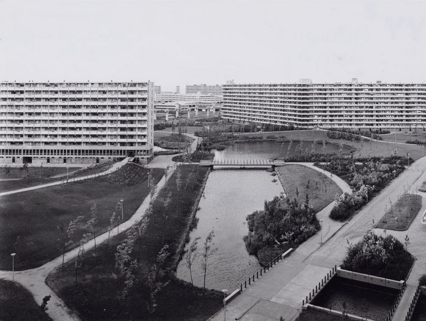
With the construction of Buitenveldert (from 1958 onwards), the original AUP was completed. However, new sections were then added to the plan because it had become clear that there was a need for more and larger dwellings. New expansion areas were designated in Amsterdam-Noord, which had ceased to be isolated with the construction of the IJ tunnel in 1968, and in Amsterdam-Zuid and Zuidoost, where the Bijlmermeer was built. The latter in particular attracted attention because it was even closer than the original AUP to the urban design ideals of CIAM, with tall flats in green space, raised roads and open areas reserved for the use of pedestrians and cyclists.
Already during the construction of the Bijlmermeer, there was a growing realization that in the first decades after the war too much attention had been focused on the expansion of Amsterdam and that the old city had suffered from neglect as a result. At first, the council tried to solve the problem through demolition and the construction of new buildings. However, some neighbourhoods objected to this policy and two districts, the Jordaan and the Nieuwmarktbuurt, played a leading role in opposing it.
In 1972, the Jordaan, for which large-scale demolition plans existed up until 1970, succesfully campaigned for a zoning plan in which existing building lines were respected. The Nieuwmarktbuurt, which already suffered severely during the Second World War, was in danger of being wiped off the map in the seventies with the construction of the metro and the planned clearances for new traffic routes. Here too, however, residents demanded the restoration of historical buildings, affordable new dwellings combined with commercial space and shops, and that new development be constructed within existing building lines. After an emotional struggle, the focus of the council’s urban renewal policy shifted to maintenance and restoration. The guiding principle in the postwar reconstruction of the Nieuwmarktbuurt was an urban design scheme, by A.E. van Eyck & Th. Bosch, based on diversity and a mix of functions.
Living, new and renewed
The emphasis on house-building continued throughout the nineties and beyond as a consequence of the persistent demand for housing. In recent decades, new residential areas have been realized both in the existing city and on the periphery. In the city, space is created by demolishing old dwellings (sometimes entire street frontages) and building new ones (Mercatorplein, Tropenpunt), by giving areas a new use (the site of the former barracks Oranje-Nassaukazerne, Meander) and by infilling gaps (Binnenwieringerstraat, Hoogte Kadijk).
For the expansion areas, concepts have been found which differ from that of the Bijlmermeer in southeast Amsterdam. Partly because of high rents and the lack of social facilities, soon after its completion this district was confronted with untenanted dwellings and problems such as social insecurity and vandalism. For this reason, since the late eighties, the focus has been on building low- and medium-rise housing at high densities. In the nineties, districts such as Nieuw Sloten and De Aker were developed in accordance with this concept. Although the aim was to integrate various functions, these new districts exude a suburban ambience. In the same period, parts of the Bijlmermeer underwent a metamorphosis in which high-rise was modified or replaced by new-build, often with the front door on the street.
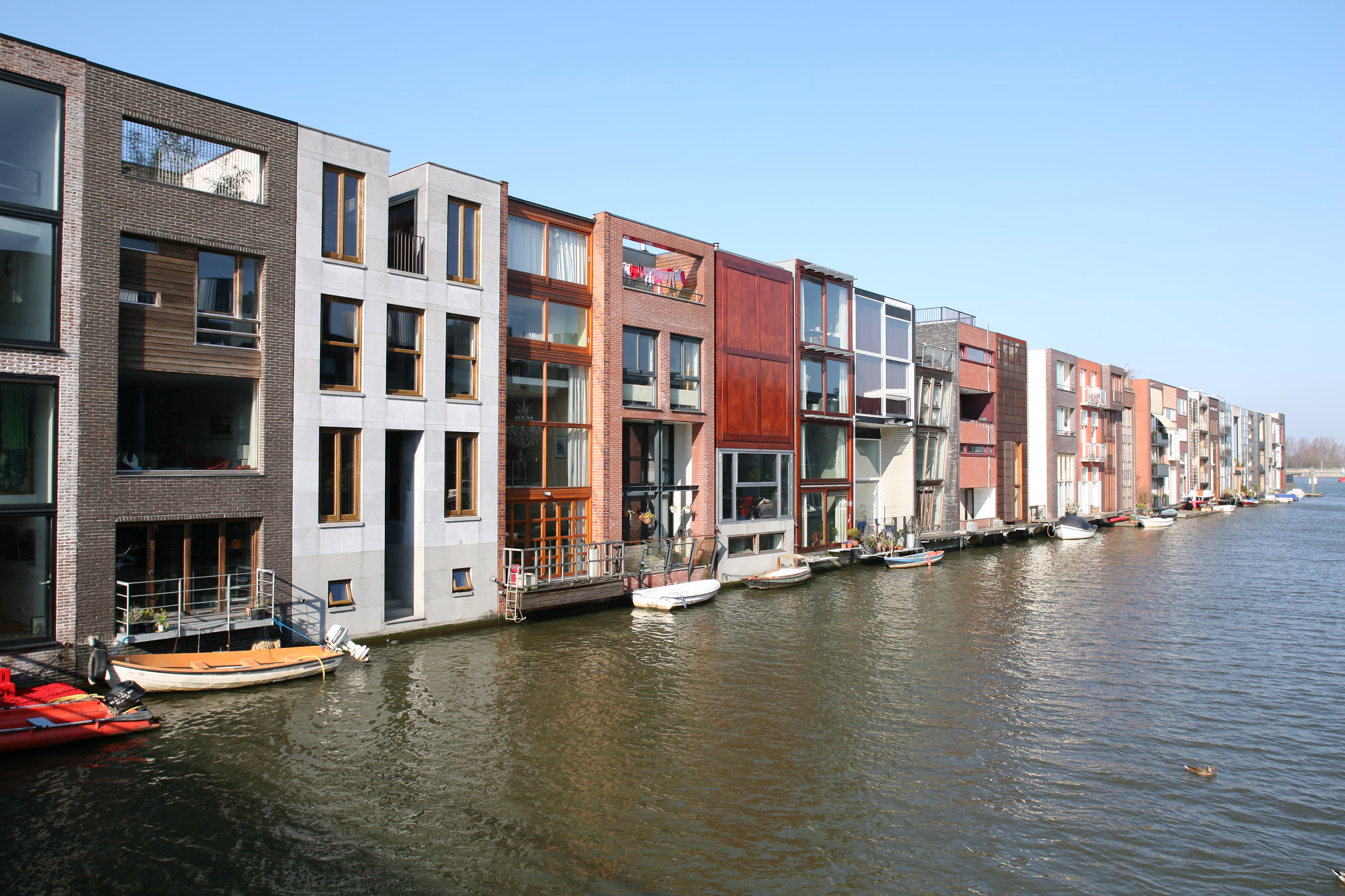
In the re-use of the former industrial islands in Oostelijk Havengebied, various urbanistic principles for the residential districts were experimented with, witness the large housing blocks on KNSM Island, the contiguous medium-rise on Java Island and the ground-accessed dwellings built at high densities on Borneo-Sporenburg. On Borneo there are also ‘private plots’, where private individuals, together with the architect of their choice, have designed and realized their own homes. The exuberant urbanistic and architectural diversity of the new residential districts reveals that construction took place here in an increasingly liberal and market-orientated climate, in which citizens have become primarily housing consumers.
Shortly after 2000, the redevelopment of Oostelijk Havengebied was more or less complete. A new focus of house-building activity is situated further eastwards in the IJmeer, where a new city district is being built on a series of artificial islands. While the continuing economic downturn of the beginning of the twenty-first century is slowing down construction, it appears not to be standing in the way of a rich diversity of urbanistic ideas and housing concepts – including private plots.
Towards the end of the twentieth century, work also began on the renewal of the Westelijke Tuinsteden, expansion areas developed in the period of reconstruction after the Second World War. In a large-scale and long-term operation, which combines demolition and new-build with renovation, the housing stock is being adapted to meet today’s living requirements. A major aim here is the integration of old and new Dutch citizens.
Economy, leisure time and infrastructure
In addition to developing residential districts, in recent decades there has been a major focus on construction aimed at strengthening Amsterdam’s economic climate. This has resulted in, among other things, the realization of new office locations, new educational buildings, new tourist and cultural facilities, and new retail complexes. Examples include the city-centre shopping complexes De Kolk and Magna Plaza, all of which were built in the nineties, and the entertainment and shopping area near the Amsterdam Arena in southeast Amsterdam, which is to be further densified in the coming years.
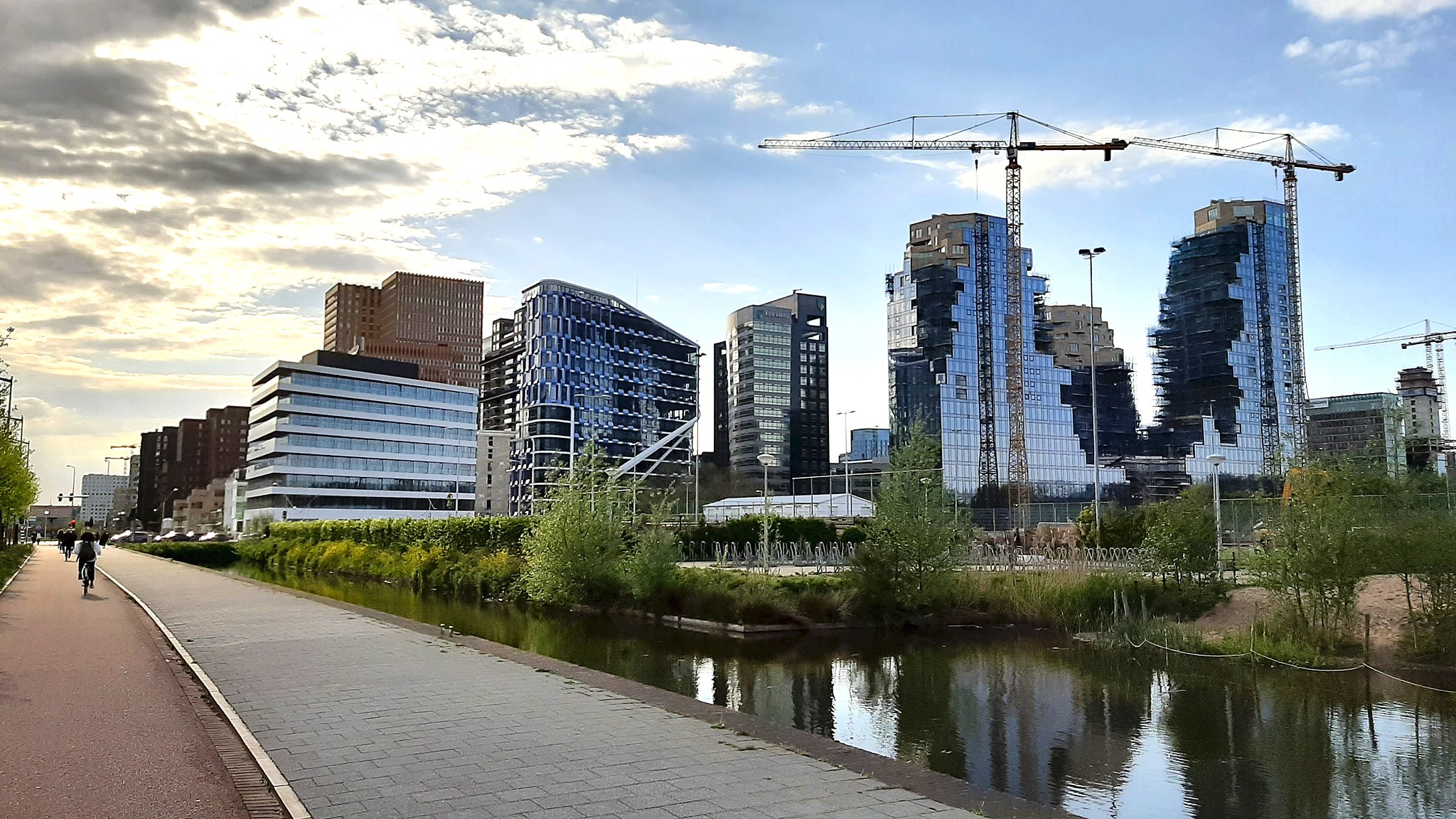
New concentrations of offices are to be found, for example, near Sloterdijk Station in the Teleport area, directly next to Amstel Station, where a small cluster of high-rise office buildings has been realized, and around the station Zuid/WTC, where, alongside the A10 orbital motorway and just a few minutes from Schiphol Airport, the Zuidas is developing. The development of this extensive business district, which according to the plans is to be upgraded with housing and cultural facilities, plays a key role in the competition with other municipalities, cities and regions in the Netherlands and beyond. The aim is to attract major companies.
The new-build for the Anne Frank House (adjoining the original building), for the storeroom of the Maritime Museum and for Architecture Centre Amsterdam, points to, among other things, the importance of Amsterdam as a (cultural-) tourist destination. The Passenger Terminal Amsterdam, which handles cruise ships, and the neighbouring Muziekgebouw/Bimhuis, are key elements in the development of the Southern IJ Waterfront, which has been the aim of Amsterdam’s urban planners since the seventies. Part of this long-term waterfront project is the transformation – currently in progress – of the two islands Westerdokseiland and Oosterdokseiland into new areas in which to live, work and linger.
Stationseiland is being radically redeveloped with the aim of improving the handling of passenger streams. It is not only a connecting link in the east/west axis, between the two neighbouring islands and beyond, as far as IJburg, but in the future it will also be an important stop on the North/South Line. This expansion of Amsterdam’s modest metro network will soon awaken Amsterdam Noord, and numerous other areas connected by this infrastructure, in a rejuvenated urban existence.